The Applied Geoinformatics and Remote Sensing Laboratory of the Institute of Geography and Earth Sciences of the Szeged University of Technology is world class in the field of remote sensing and satellite image analysis. The research team's studies allow for a more efficient analysis of crop plants, also over a wider time span. The cooperating partner of the project is the Mezőhegyes National Stud Farm and Tangazdaság Zrt.
Geoinformatics, the science of spatial information processing, is multidisciplinary in nature, dealing with the interface between engineering, computer science, natural sciences and other fields such as agricultural and social sciences, and earth observation (space remote sensing), building on their paradigms. A report on the hyperspectral remote sensing project of the research team of the University of Szeged was previously published on the university portal. The DESIS hyperspectral camera on board the International Space Station took images of the South-Eastern Great Plain sample area based on a programming and data collection research plan submitted by the Szeged researchers. The processing of the measurement results and the space images based on the ground reference data, with the professional support of the Mezőhegyes National Stud Farm and Tangazdaság Zrt, was carried out at the end of 2022. Of these, the research group's publication is the third most cited paper among the more than 741 articles published this year in the IEEE (Institute of Electrical and Electronics Engineers) Journal of Selected Topics in Applied Earth Observations and Remote Sensing with 19 independent references.
The Applied Geoinformatics and Remote Sensing Laboratory of the Institute of Geography and Earth Sciences of the University of Szeged is world class in the field of remote sensing and satellite image analysis.

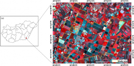
The study area is (a) the administrative boundary of Hungary and (b) the RGB false colour composite image of the DESIS Earth Observation Imaging Spectrometer taken on 16 June 2022
IEEE is the world's largest technical organisation dedicated to the advancement of technology globally. Its members inspire a community through highly cited publications, conferences, technology standards, and professional and educational activities to build a sustainable future. Their scientific journal, IEEE Xplore, is one of the leading professional journals in which cutting-edge research is published. The US journal is Q1 rated with an impact factor of 5.5, which means that it is well known and respected in the scientific community, and its publications are widely cited and referenced.
The research group of the University of Szeged has 8 Q1 publications in the field of earth observation this year, including crop monitoring, precision agriculture, crop estimation, multi- and hyperspectral space imagery, time series analysis. One of their projects focused on the potential applications of space technology in crop production. SZTE researchers analysed space images from Hungary.
The publication is very popular in professional circles, as it is the third most cited among the 741 articles in this year's volume.

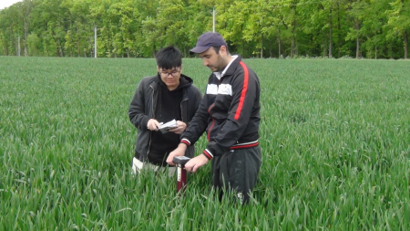
Bui Dang Hung és Nizom Farmonov doktorandusz hallgatók terepi mérése talajnedvesség mérővel a mintaterületen
The most important result of the research team, consisting of Nizom Farmonov, Khilola Amankulova, Uzbek PhD students, Dr. András Gudmann, Dr. Bui Dang Hung, Dr. József Szatmári and Dr. László Mucsi, is that the hyperspectral space images can be efficiently analysed at the parcel level by machine learning classification of different agricultural crops over the whole phenological period. The relationship between measurable and ascertainable crop yield and spectral properties and the identification of different yield areas, the so-called management zones, within the table. Continuous spectral information can be linked to the biophysical properties of plants, the occurrence of plant diseases or spatial differences in soils. Using time series space images before harvest, the researchers have estimated yields with high accuracy for soybean, winter wheat and sunflower fields.
- Geoinformatics has been present in the teaching and research portfolio of the SZTE for nearly 30 years, we are a founding member of the Association of Applied Geoinformatics Laboratories (AGILE) and the European Association of Remote Sensing Laboratories (EARSEL). From the diverse applications of geoinformatics systems (GISystems), GIScience, the science of spatial information, emerged in the early 2000s and is now the basis of one of the fastest growing technology industries, the spatial data infrastructure and industry. This resulted in the development of the Master's degree in Geoinformatics in Szeged and the establishment of the degree program, which will be launched in 2023 in 5 other Hungarian higher education institutions besides the SZTE. The SZTE has also launched Hungarian-language full-time and part-time courses, as well as English-language courses, said Dr. László Mucsi, the leader of the research team.

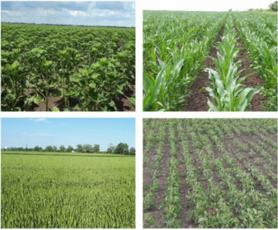
Photos of the main plant species in the study area ( 14 June 2022)
The results of basic and applied scientific research can be used very quickly in the economy, in agriculture. Publications, especially articles in open access journals, can be distributed worldwide. The members of the research team would like to thank the SZTE for its Open Access publication support, without which the publications would not have been possible. The publications strengthen the links between science and potential users, generating further new R&D projects.
- The parcel-level precision agriculture monitoring system will be complemented with data from the EnMAP hyperspectral satellite, which was launched in spring 2023 and used exclusively for research purposes, based on our newly approved project proposal. In 2023, the DESIS research project will be extended to cover land cover and land use mapping in 4 Hungarian cities, Budapest, Debrecen, Szeged and Székesfehérvár. Nearly 50 time series space images have been acquired and are currently being processed.
The project has highlighted the huge potential of hyperspectral satellite imagery for agriculture. Studies carried out in the fields of the National Stud Farm and Tangazdaság Zrt. show that these space images can be used not only to monitor the health of the crop and its response to certain treatments, but also to assess soil nutrient and water management indicators. This opens up a number of research topics and further opportunities for cooperation between universities, research institutes and the productive agricultural sector, in which the farmers are responsible for raising the most important problems that can be answered by researchers in geoinformatics, including remote sensing science," said Norbert Kovács, CEO, Nemzeti Ménesbirtok és Tangazdaság Zrt..
Ferenc Lévai
Photos: Applied Geoinformatics and Remote Sensing Laboratory, Institute of Geography and Earth Sciences - SZTE

